Use APKPure App
Get 潮時と天気 - 潮見表, 潮汐, 予報, 潮位表, 釣り old version APK for Android
It is an application that shows the tide and weather conditions for fishermen and anglers. We provide various weather information so that you can easily understand the sea conditions in all regions of Japan.
A must-have app for those who love the sea!
Please try installing the marine weather app "Tide Times and Weather" that can be used by sea fishing, skin scuba, surfing, island travel, photographers, and fishermen.
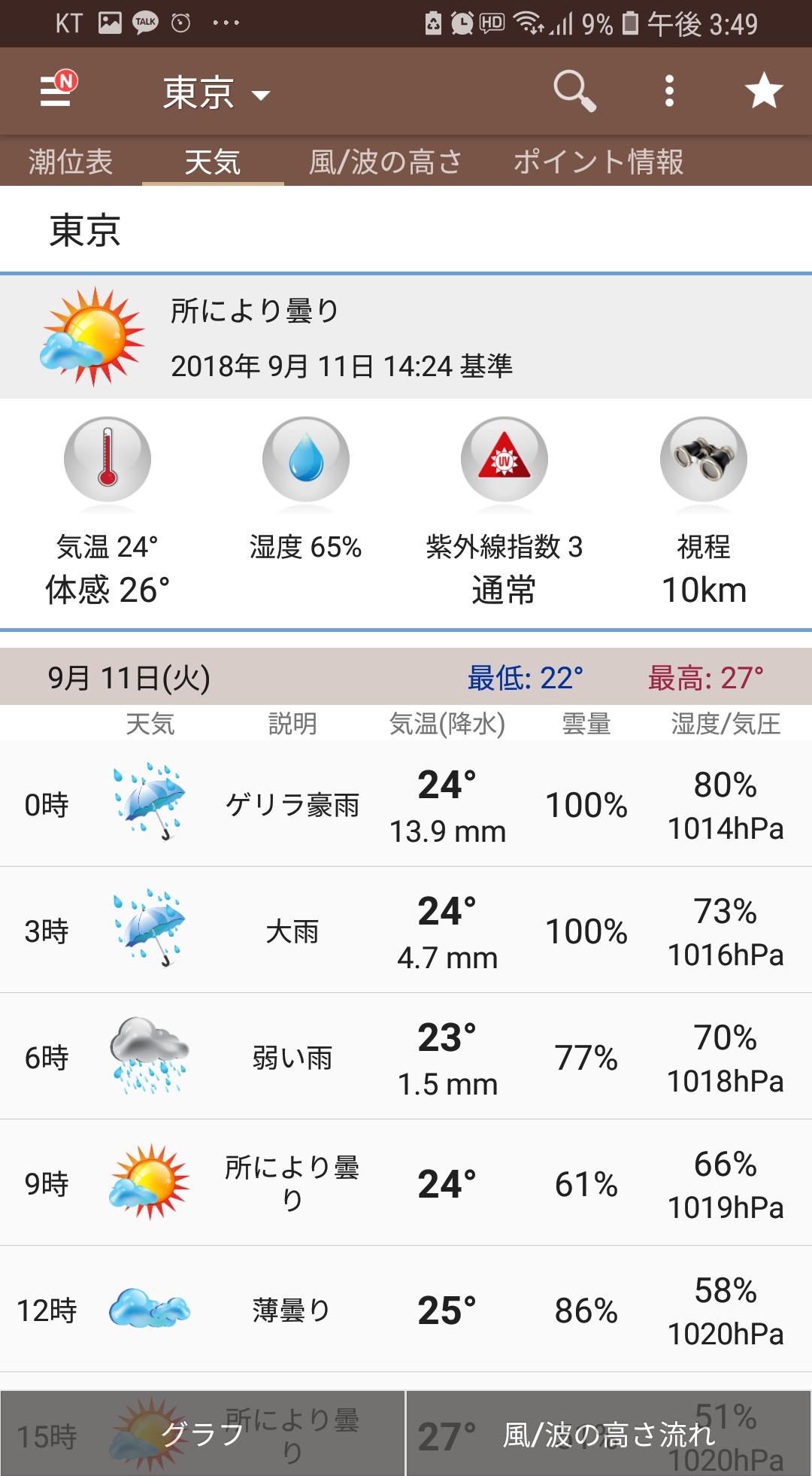
This app allows you to view the tide table, weather, wind direction and speed, sea forecast, humidity, visibility, cloud cover, UV index, snow, rain forecast, etc. that are necessary for fishing.
This is a simple app that can be easily installed and used by sea anglers and freshwater anglers of all ages.
We will continue to update this information for anglers who love the sea.
********* Menu information ***********
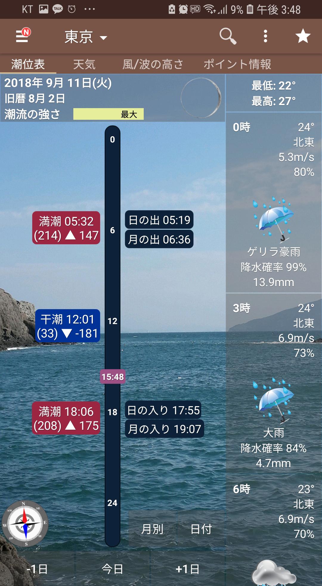
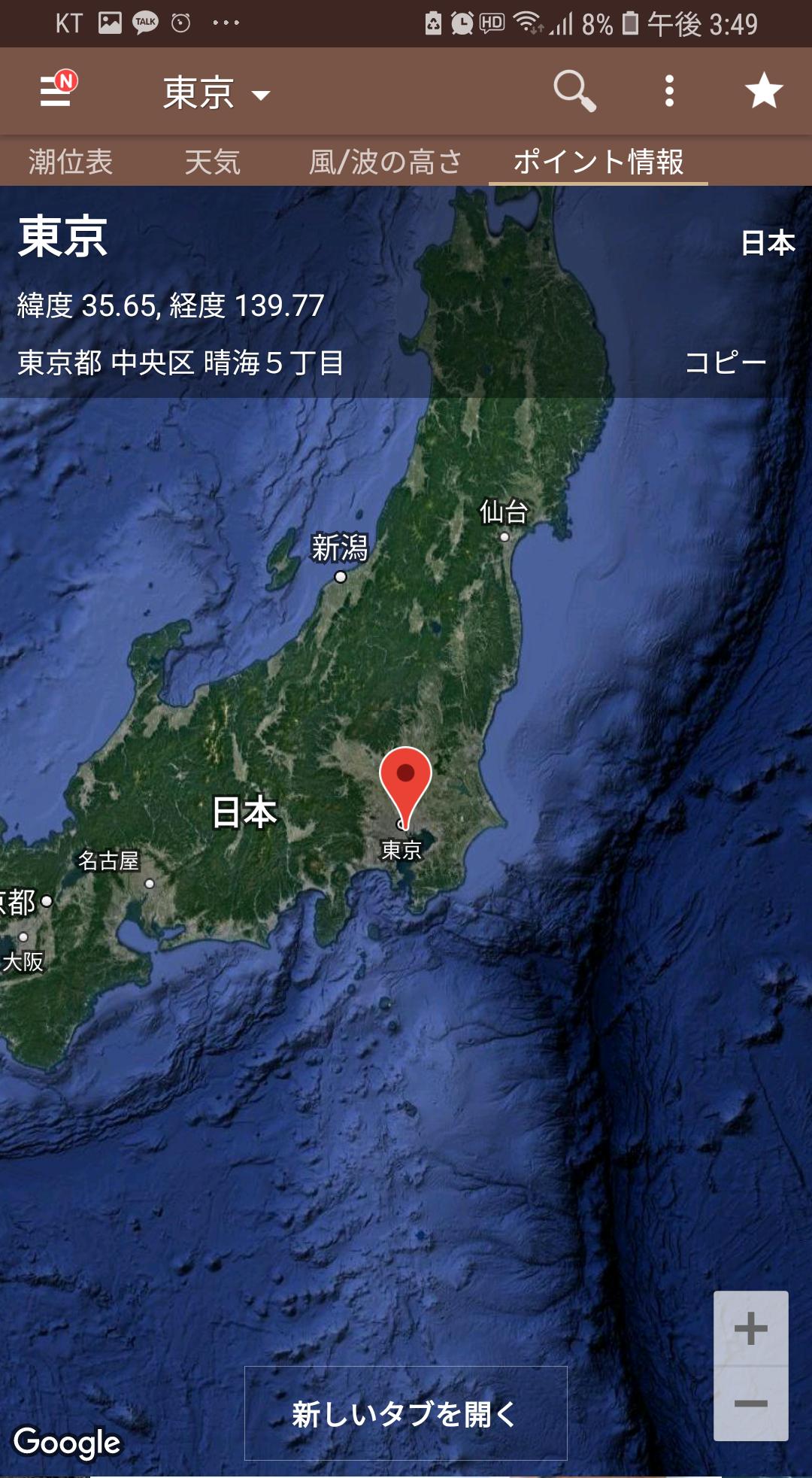
**Main Menu - Tide Table, (Tide Table, Tide Forecast)/Forecast/Wind, Wave Height/Point Information
1.Fishing information - View the entire area/Monthly tide table/Sea fishing video
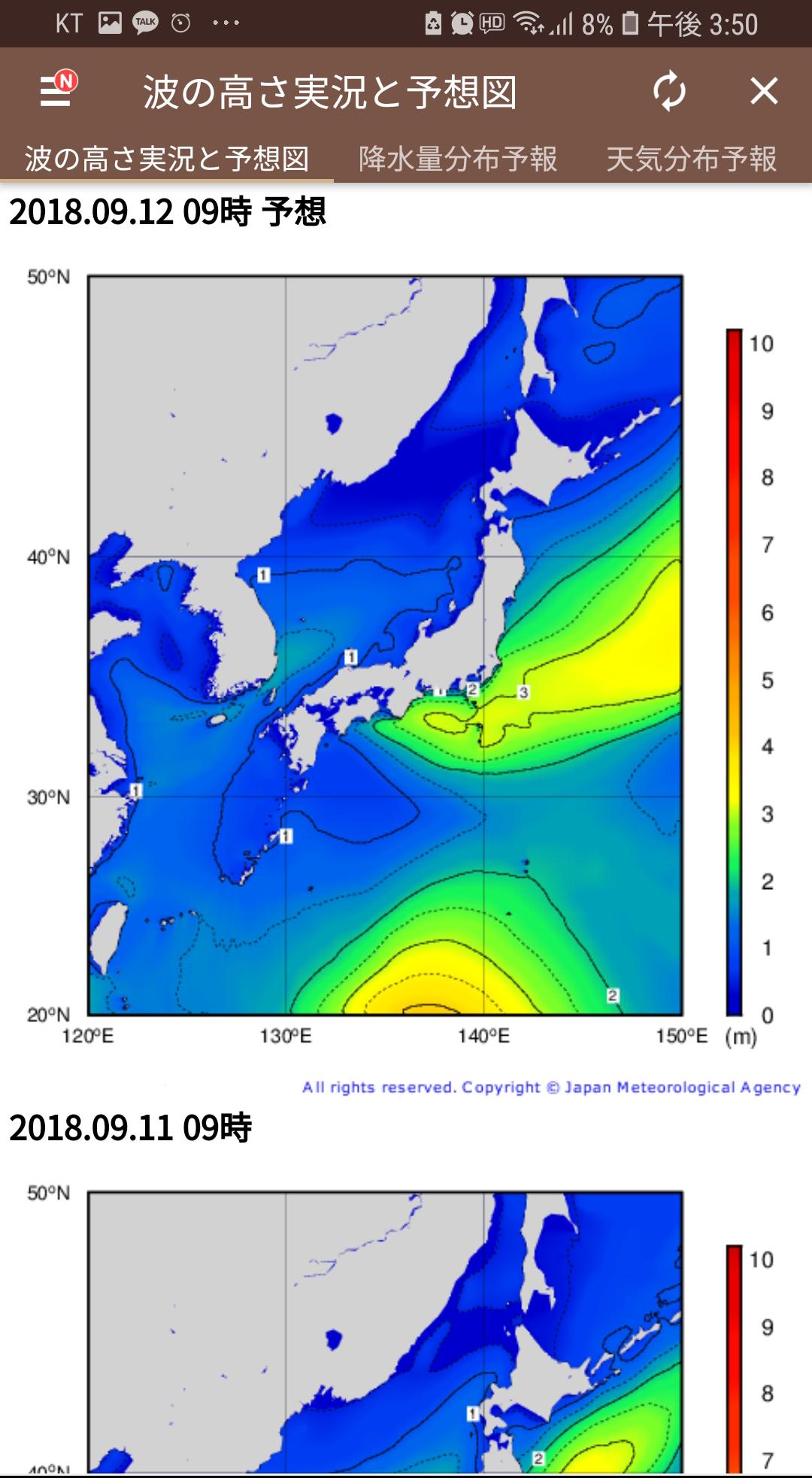
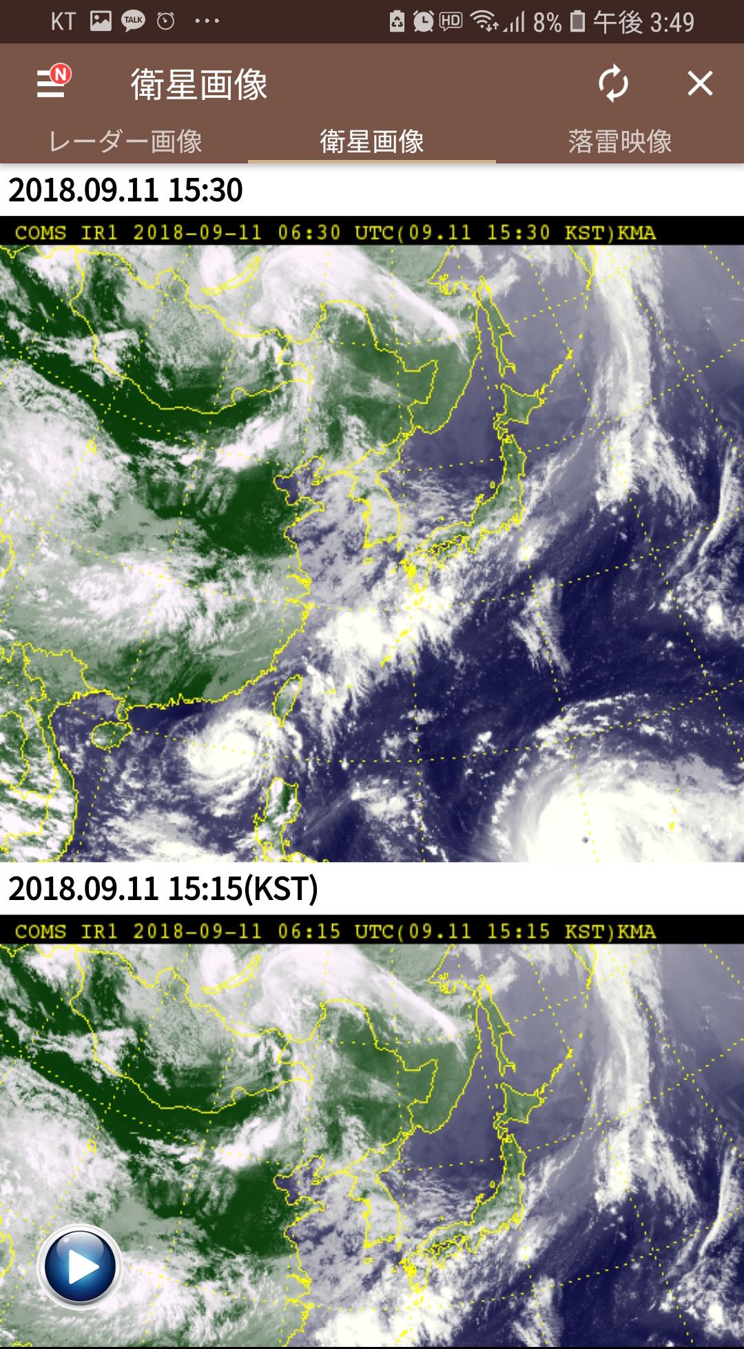
2. Weather images - radar images/satellite images/lightning images
3. Japan Meteorological Agency - Wave height live and forecast map/precipitation distribution forecast/weather distribution forecast/temperature distribution forecast/snowfall distribution forecast
4. Typhoon forecast - Japan typhoon forecast/Korea typhoon forecast/Taiwan typhoon forecast
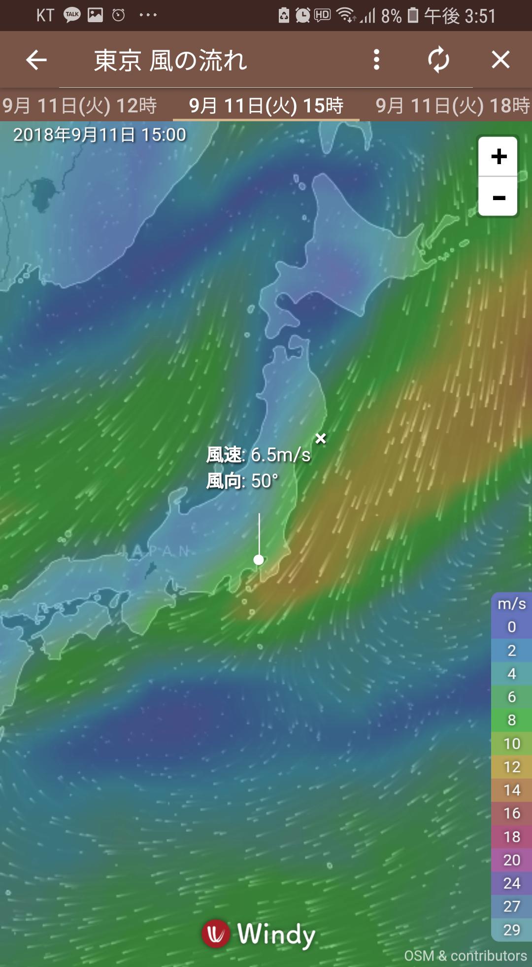
5. Comparison of numerical values at sea - Daily average sea water temperature / Wind flow trends / Rain and cloud trends / Wave flow trends / Ocean current diary chart / Water temperature diary chart / Salinity diary chart
6.Fishing equipment - compass/flashlight
***************************************************
Benefits of “tide and weather”
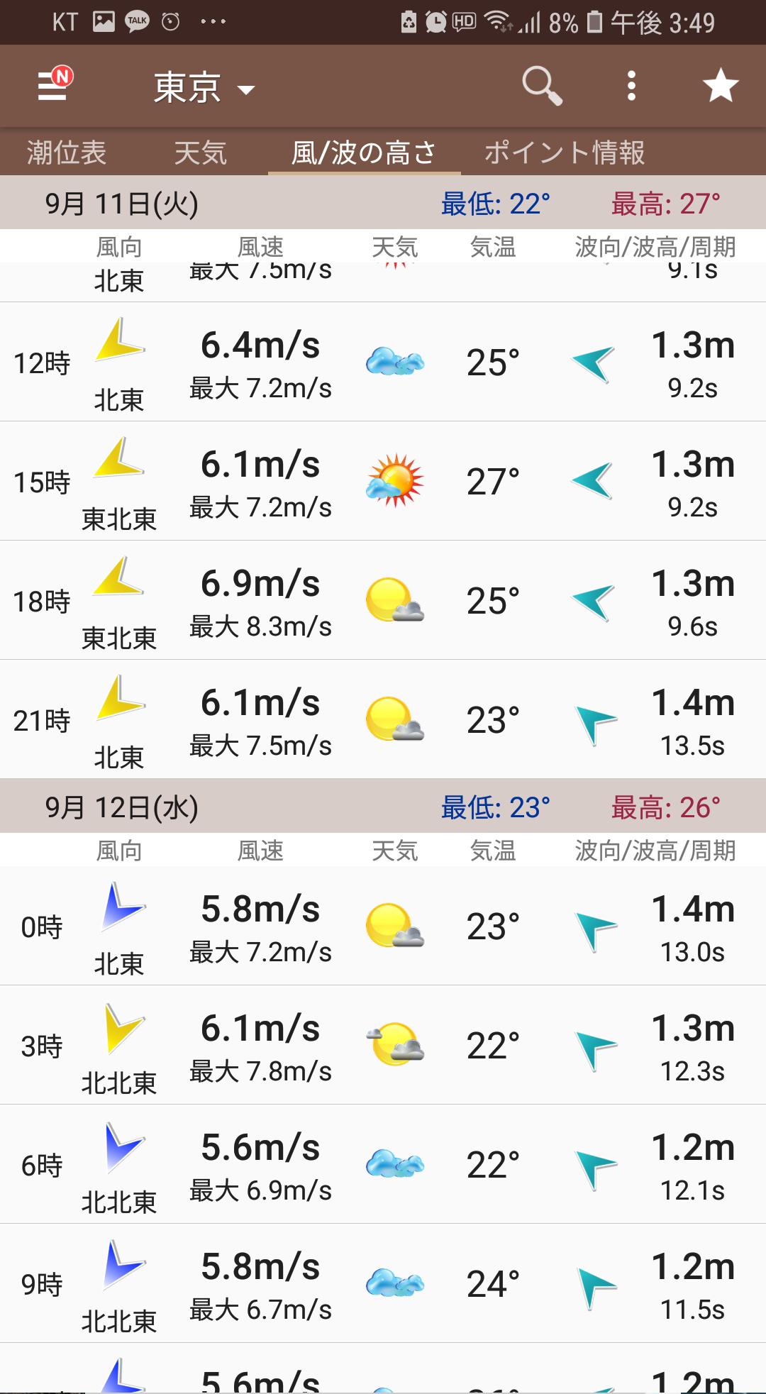
1. Wind/wave height menu
●It is the first in Japan to provide accurate wind speed/direction at 3-hour intervals, and can forecast up to 14 days, making it useful for many leisure activities at sea.
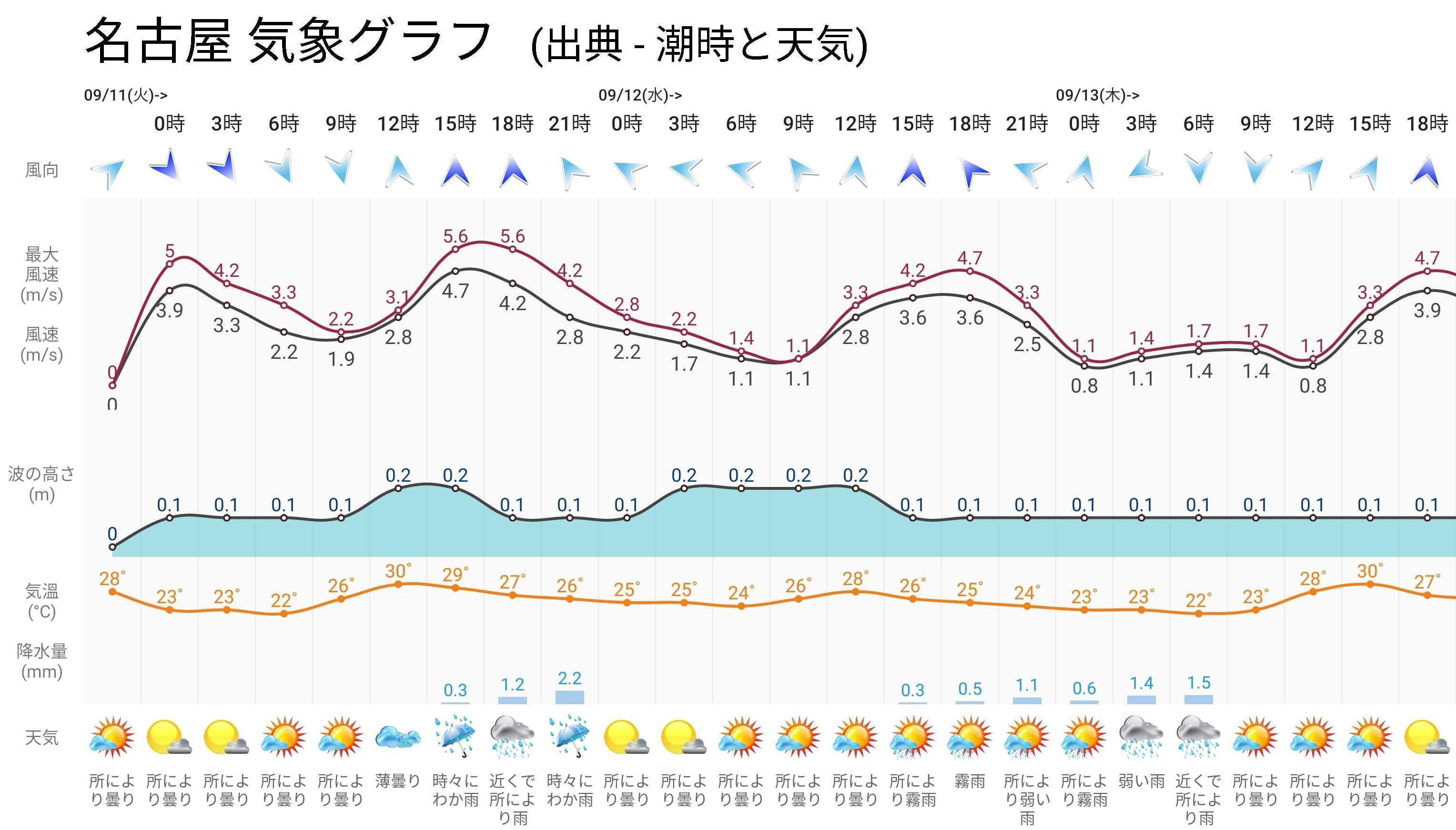
-New weather graph function that displays wind direction/wind speed/weather/precipitation/temperature/wave height on one screen - The ability to save images and share them on SNS is very useful.
2. Low tide/high tide notification settings
●You can register the ebb and flow notifications for each region and receive the notifications as a ringtone.
●You can set favorite areas and manage them all at once.
3. 240 locations providing tide and weather information
●Provides tide charts and weather forecasts for approximately 240 regions.
●You can easily search for many different regions using your own favorites and search function.
4.Icon and background screen setting function
●Set your own icon with a total of 5 icon sets
●You can register photos and images taken directly, and you can specify your own original background screen.
5. Reinforcement of various weather information functions
●For the accuracy of weather forecasting, we provided weather data through the application of various numerical forecasting models, and compared the various weather conditions to ultimately make more accurate judgments.
●Comprehensive provision of a variety of weather data that could not be viewed through apps until now
6.Other useful information/functions
●Various additional functions are provided such as water flow strength/monthly tide/fishing video/flashlight function.
●A "Menu Favorites" feature has been added that allows you to easily view the menus you use the most.
-A function has been added that allows you to save not only the wind/wave height menu but also the tide/weather/wind wave height/point information on the main screen as an image and share it on SNS.
##Information provided
Tide times (tidal forecasts and information) - Tide times, ebb and flow times and tide level changes, tide level observation information (tide level, water temperature, wind direction, air temperature, wind speed, atmospheric pressure, salinity concentration, sunrise/sunset times)
Weather - regional temperature and humidity, wind speed/direction, cloud cover, UV index, visibility, perceived temperature, 3-hourly weather information, 14-day long-term forecast
Wind/Wave Height - Wave height and wind direction/speed information for near and far seas
##Tide and weather usage fields
-You can understand the tide and weather conditions for beach fishing, boat fishing, lure fishing, sea fishing (distance fishing, walking, lure fishing, rocky float fishing).
-A must-have app for individuals and clubs to understand the sea weather conditions before fishing.
-A variety of fields including photographers, divers, surfers, fishermen, and captains can easily understand conditions such as tidal forecasts, marine weather, national weather, typhoons, sunrise/sunset, and water temperature.
##Area where information is displayed
▲ Hokkaido
• Kiritappu • Kushiro • Tomakomai West • Tomakomai East • Hanasaki • Rausu • Abashiri • Monbetsu • Wakkanai • Ishikari Shinko • Shiraoi • Rumoi • Setana • Urakawa • Kutsugata • Esashi • Mori • Nemuro • Esashi • Matsumae • Oshiro • Iwanai • Otaru • Suttsu • Muroran • Okushiri Port • Okushiri • Yoshioka • Tokachi • Hakodate
▲ Aomori prefecture
• Aomori • Tatsuhi • Fukaura • Asamushi • Oma • Ominato • Hachinohe Port • Hachinohe • Shimokita • Mutsu Ogawara
▲ Akita Prefecture
• Funagawa Port • Akita • Oga
▲ Iwate Prefecture
• Kamaishi • Miyako • Ofunato • Kuji
▲ Miyagi Prefecture
• Ayukawa • Ishinomaki • Shiogama • Sendai Shinko
▲ Yamagata Prefecture
• Nezugaseki • Tobishima • Sakata
▲ Fukushima prefecture
• Soma • Onahama
▲ Ibaraki Prefecture
• Kashima • Hitachi • Oarai
▲ Chiba Prefecture
• Tateyama • Choshi Fishing Port • Kisarazu • Fura • Chiba Port • Chiba • Katsuura
▲ Tokyo
• Kozushima • Chichijima • Tokyo • Okada • Minamitorishima • Hachijojima (Kamiminato) • Hachijojima (Yaene) • Miyakejima (Ako) • Miyakejima (Tsubota)
▲ Kanagawa Prefecture
• Shonan Port • Aburatsubo • Yokosuka • Yokohama • Honmoku • Kawasaki • Odawara • Keihin Port
▲ Shizuoka Prefecture
• Maisaka • Irozaki • Tago • Yaizu • Shimizu Port • Omaezaki • Minamiizu • Uchiura • Ito • Shimoda
▲ Ishikawa Prefecture
• Kanazawa • Wajima • Noto • Nanao
▲ Toyama Prefecture
• Shinminato • Toyama • Fushiki Toyama
▲ Niigata Prefecture
• Awashima • Naoetsu • Kashiwazaki • Niigata West Port • Niigata East Port • Ogi • Sado • Ryotsu
▲ Fukui Prefecture
• Tsuruga • Mikuni
▲ Aichi Prefecture
• Onizaki • Akabane • Kinuura • Katahara • Nagoya • Mikawa
▲ Mie Prefecture
• Toba • Kumano • Owase • Yokkaichi Port
▲ Kyoto Prefecture
• Maizuru • Miyazu
▲ Osaka Prefecture
• Kansai Airport • Tannowa • Izumiotsu • Kishiwada • Osaka • Sakai
▲ Hyogo Prefecture
• Nishinomiya • Kobe • Sumoto • Tsuiyama • Ei • Akashi • Amagasaki • Himeji (Shikama)
▲ Wakayama Prefecture
• Shirahama • Kainan • Uragami • Gobo • Wakayama • Kushimoto • Shimotsu
▲ Shimane Prefecture
• Saigo • Hamada
▲ Okayama Prefecture
• Mizushima •Uno
▲ Hiroshima Prefecture
• Itozaki •Takehara • Hiroshima • Kure
▲ Yamaguchi Prefecture
• Susa • Chofu • Hagi • Tanokubi • Tokuyama • Teshemachi • Ube • Oyama-no-hana • Minamikazedomari • Mitajiri
▲ Tokushima Prefecture
• Yuki Awa • Tachibana • Hiwasa • Komatsushima
▲ Kagawa Prefecture
• Takamatsu • Aoki • Tadotsu • Yoshima
▲ Ehime Prefecture
• Hatohama • Matsuyama • Kurushima Route • Niihama • Uwajima • Iyo Mishima • Kojima, Imabari City • Imabari
▲ Kochi Prefecture
• Kochi Shimoda • Kochi • Susaki • Kaura • Katashima • Cape Muroto • Tosashimizu • Kure
▲ Fukuoka Prefecture
• Aohama • Moji • Karita • Sunatsu • Nikkei • Omuta • Hakata
▲ Saga Prefecture
• Oura • Karatsu • Kariya
▲ Nagasaki Prefecture
• Nagasaki • Gonoura • Fukue • Empress • Hirado Seto • Tsushima Hitakatsu • Tsushima • Kuchinotsu • Izuhara • Sasebo
▲ Kumamoto Prefecture
• Reihoku • Kumamoto • Minamata • Hondo Seto • Yatsushiro • Misumi
▲ Oita Prefecture
• Oita • Beppu • Saeki
▲ Miyazaki Prefecture
• Hososhima • Aburatsu • Miyazaki
▲ Kagoshima Prefecture
• Kagoshima • Akune • Nishinoomote • Tanegashima • Makurazaki • Shibushi • Amami • Odomari • Naze • Nakanoshima
▲ Okinawa Prefecture
• Naha • Iriomote Island • Ishigaki Island • Nanjo • Miyako Island • Minamidaito Island • Nakagusuku Bay Port • Yonaguni Island
##Disclaimer and Terms of Use
Please use the data of this app at your own risk. Also, it is not valid for navigational information. The "Tide Time and Weather" production team is not responsible for any trouble, direct or indirect damage, or potential damage that may occur when analyzing or using the information contained in this application.
#### This app is not an official government app, and is only provided with source data.
Last updated on Mar 11, 2025
- サービスの安定化とエラーの改善
Latest Version
![]() 1.1.0
1.1.0
Uploaded by
Казуто Киригаяа
Requires Android
Android 5.0+
Category
Report
Discover what you want easier, faster and safer.

潮時と天気 - 潮見表, 潮汐, 予報, 潮位表, 釣り
1.1.0 by ATC Team
Mar 11, 2025